
Indianapolis ITS Architecture

This website provides access to the Indianapolis Regional Intelligent Transportation System (ITS) Architecture. The architecture defines the functional relationships between the transportation systems across the Indianapolis region, affording the agencies and organizations at the state, regional and local levels information they can use to plan and develop transportation solutions to meet the region's needs.
The Indianapolis Metropolitan Planning Organization (IMPO) began a project in 2023 to update Regional ITS Architecture to reflect the latest transportation systems implementations and to identify what will potentially be needed to support and address the transportation needs over the next ten years. The revised architecture complies with the FHWA 23 CFR Rule 940 requirements and is compatible with the Architecture Reference for Cooperative and Intelligent Transportation (ARC-IT).
The purpose of this Indianapolis Regional ITS Architecture website is to present the ITS architecture that reflects the intelligent transportation system architecture status and vision of the stakeholders represented across the Indianapolis Region.
The Indianapolis Regional ITS Architecture (RITSA) is a roadmap for transportation systems integration for ITS services over a 10-year time horizon. The Indianapolis RITSA was updated and is compatible with the latest version of the Architecture Reference for Cooperative and Intelligent Transportation (ARC-IT) which makes available all of the ARC-IT content for use in updates to the Indianapolis RITSA.
The updated Indianapolis RITSA addresses change requests submitted by stakeholders and documented in the Architecture Maintenance Log. Indianapolis RITSA Update Report and the revised Indianapolis RITSA database are available under the Resource tab.
The Indianapolis RITSA represents a shared vision of how each agencies' systems will work together in the future, sharing information and resources to provide a safer, more efficient, and more effective transportation system for travelers in the Indianapolis Region.
The Indianapolis RITSA functionally defines the interactions and information exchanges between the intelligent transportation systems operated and maintained by the various public and private sector organizations in the region. The RITSA includes existing systems as well as planned systems and services that are needed to deliver the transportation services to improve safety, mobility and efficiency across the region.
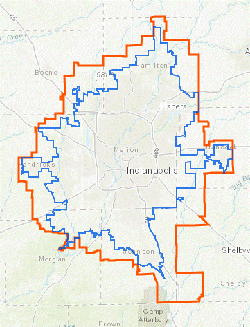
The geographic scope of the Indianapolis RITSA includes the jurisdictions of public agencies at the Indianapolis DOT, Metropolitan Planning Area, County, City, and Town levels. The primary public sector jurisdictional boundaries making up the Indianapolis RITSA geographic scope include:
Indiana Department of Transportation (INDOT) Districts including Greenfield, Crawfordsville, and Seymour Districts.
Metropolitan Planning Areas: Indianapolis MPO
Counties: Boone County, Hamilton County, Hancock County, Hendricks County, Johnson County, Marion County, Morgan County, Shelby County
Cities and Towns: Indianapolis, City of Beech Grove, City of Carmel, City of Fishers, City of Franklin, City of Greenfield, City of Greenwood, City of Lawrence, City of Noblesville, City of Southport, City of Westfield, Town of Avon, Town of Bargersville, Town of Brooklyn, Town of Brownsburg, Town of Cicero, Town of Cumberland, Town of Danville, Town of McCordsville, Town of Mooresville, Town of New Palestine, Town of Pittsboro, Town of Plainfield, Town of Speedway, Town of Whiteland, Town of Whitestown, Town of Zionville
Planning Partners: IndyGo, CIRTA, Indiana DOT, Federal Highway Administration, Federal Transit Administration, Indianapolis Airport, Ports of Indiana
The Indianapolis RITSA is used by transportation agencies to define and transportation planners to plan ITS projects that address transportation needs. The RITSA provides a functional framework into which an ITS project is integrated. This framework is used as a reference from which a project is defined. Using the Regional Architecture Development for Intelligent Transportation (RAD-IT) software tool, an agency will choose the transportation services, identify the systems to be included, and then select the information exchanges to tailor the project to address the stakeholders' transportation needs.
The Indianapolis RITSA, including the defined ITS projects, is used as a reference in transportation planning activities at all levels to coordinate and integrate ITS across the region. Integration opportunities are considered by stakeholders as their projects are defined using the RITSA content as a guide. The RITSA offers a broader picture that the stakeholders take into consideration when thinking of the project definition. The project definitions take into account other systems and services that may be germane to the project scope and future expansion. The projects are defined within the RITSA domain and it is the projects where the integration opportunities are codified. The project definitions in the RITSA are the first opportunity for integration considerations. Project development in further detail in systems engineering is another opportunity. The RITSA is a primary source for those integration opportunities in both cases.
The previous version of the Indianapolis RITSA was used as the baseline for the update. Starting in May 2023, stakeholders participated in a workshop to provide information for the architecture update. Additional information was gathered from documents provided by stakeholders, as well as through publicly available planning documents. The information gathered was used to initiate the process of revising the RITSA. The focus of the Indianapolis RITSA update is to identify actual information exchange requirements between specific ITS elements in the region.
Going forward, the architecture will be periodically reviewed and assessed for revisions that are necessary to reflect current ITS project and system deployment conditions and to incorporate change requests submitted by stakeholders. An Architecture Maintenance Log is used to list and manage the changes planned for each maintenance cycle.
Architecture updates are made using the RAD-IT software which is based on ARC-IT. ARC-IT and the RAD-IT software are accessible on the ARC-IT website at www.arc-it.net.
The Indianapolis Metropolitan Planning Organization (IMPO) values each individual's civil rights and wishes to provide equal opportunity and equitable service. As a recipient of federal funds, the IMPO conforms to Title VI of the Civil Rights Act of 1964 (Title VI) and all related statutes, regulations, and directives, which provide that no person shall be excluded from participation in, denied benefits of, or subjected to discrimination under any program or activity receiving federal financial assistance from the IMPO on the grounds of race, color, age, sex, sexual orientation, gender identity, disability, national origin, religion, income status or limited English proficiency. The IMPO further assures every effort will be made to ensure nondiscrimination in all of its programs and activities, regardless of whether those programs and activities are federally funded. For any and all inquiries regarding the application of this accessibility statement and related policies, please view the IMPO Title VI page, indympo.org/policies.
If information is needed in another language, contact 317-327-5136. Si se necesita información en otro idioma, comuníquese con 317-327-5136.
This plan was prepared in cooperation with the State of Indiana, the Indiana Department of Transportation, and the Federal Highway Administration. This financial assistance notwithstanding, the contents of this document do not necessarily reflect the official view or policies of the funding agencies.