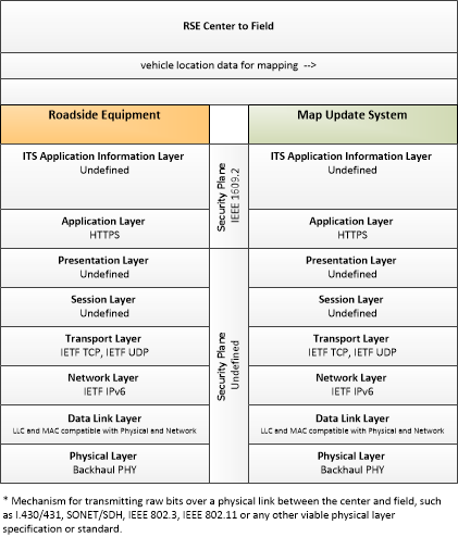
Link Type: Center to Field
Roadside Equipment --> Map Update System:
vehicle location data for mapping
Definitions
vehicle location data for mapping (Information Flow): Aggregate vehicle location data collected to support map data creation and refinement.
Roadside Equipment (Source Physical Object): 'Roadside Equipment' (RSE) represents the Connected Vehicle roadside devices that are used to send messages to, and receive messages from, nearby vehicles using Dedicated Short Range Communications (DSRC) or other alternative wireless communications technologies. Communications with adjacent field equipment and back office centers that monitor and control the RSE are also supported. This device operates from a fixed position and may be permanently deployed or a portable device that is located temporarily in the vicinity of a traffic incident, road construction, or a special event. It includes a processor, data storage, and communications capabilities that support secure communications with passing vehicles, other field equipment, and centers.
Map Update System (Destination Physical Object): The 'Map Update System' represents a provider of map databases used to support ITS services. It supports the provision of the map data that are used directly by vehicles (e.g., roadway and intersection geometry data sets), travelers (e.g., navigable maps used for route guidance and display maps used at traveler information points), system operators (e.g., map data used by Traffic Operators to monitor and manage the road network, and map data used by Fleet Managers to manage a vehicle fleet). It may represent a third-party provider or an internal organization that produces map data for agency use. Products may include simple display maps, map data sets that define detailed road network topology and geometry, or full geographic information system databases that are used to support planning and operations.
Included In
This Information Flow is in the following Applications:
This Information Flow is in the following Application Objects:
Communication Diagrams
The communication diagram(s) can be viewed in SVG or PNG format and the current format is SVG. Switch to PNG format.
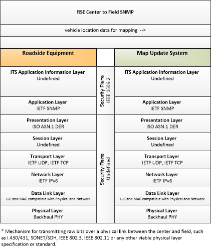
This profile identifies applicable standards for Center to Field communications with RSEs. This profile uses the Simple Network Management Protocol (SNMP), an Internet-standard protocol for managing devices on IP networks.
Characteristics
Architectural:
| Characteristic | Value |
|---|---|
| Time Context | Recent |
| Spatial Context | Regional |
| Acknowledgement | False |
| Cardinality | Unicast |
| Initiator | Source |
Security
This information flow triple is in the following applications with the following security levels.
| Information Flow Security | |||||
|---|---|---|---|---|---|
| Application | Confidentiality | Integrity | Availability | ||
| Basis | Basis | Basis | |||
| Security levels have not been defined yet. | |||||