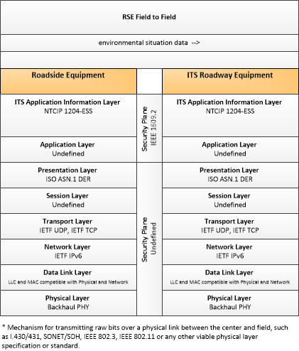
Link Type: Field to Field
Roadside Equipment --> ITS Roadway Equipment:
environmental situation data
Definitions
environmental situation data (Information Flow): Aggregated and filtered vehicle environmental data collected from vehicle safety and convenience systems including measured air temperature, exterior light status, wiper status, sun sensor status, rain sensor status, traction control status, anti-lock brake status, and other collected vehicle system status and sensor information. This information flow represents the aggregated and filtered environmental data sets that are provided by the RSE to the back office center. Depending on the RSE configuration and implementation, the data set may also include environmental sensor station data collected by the RSE.
Roadside Equipment (Source Physical Object): 'Roadside Equipment' (RSE) represents the Connected Vehicle roadside devices that are used to send messages to, and receive messages from, nearby vehicles using Dedicated Short Range Communications (DSRC) or other alternative wireless communications technologies. Communications with adjacent field equipment and back office centers that monitor and control the RSE are also supported. This device operates from a fixed position and may be permanently deployed or a portable device that is located temporarily in the vicinity of a traffic incident, road construction, or a special event. It includes a processor, data storage, and communications capabilities that support secure communications with passing vehicles, other field equipment, and centers.
ITS Roadway Equipment (Destination Physical Object): 'ITS Roadway Equipment' represents the ITS equipment that is distributed on and along the roadway that monitors and controls traffic and monitors and manages the roadway itself. In CVRIA, this physical object represents all of the other ITS field equipment that interfaces with and supports the Connected Vehicle Roadside Equipment (RSE). This physical object includes traffic detectors, environmental sensors, traffic signals, highway advisory radios, dynamic message signs, CCTV cameras and video image processing systems, grade crossing warning systems, and ramp metering systems. Lane management systems and barrier systems that control access to transportation infrastructure such as roadways, bridges and tunnels are also included. This object also provides environmental monitoring including sensors that measure road conditions, surface weather, and vehicle emissions. Work zone systems including work zone surveillance, traffic control, driver warning, and work crew safety systems are also included.
Included In
This Information Flow is in the following Applications:
- Cooperative Adaptive Cruise Control
- Eco-Cooperative Adaptive Cruise Control
- Intelligent Traffic Signal System
- Roadside Lighting
- Variable Speed Limits for Weather-Responsive Traffic Management
This Information Flow is in the following Application Objects:
Communication Diagrams
The communication diagram(s) can be viewed in SVG or PNG format and the current format is SVG. Switch to PNG format.
Characteristics
Architectural:
| Characteristic | Value |
|---|---|
| Time Context | Recent |
| Spatial Context | Adjacent |
| Acknowledgement | False |
| Cardinality | Unicast |
| Initiator | Source |
Security
This information flow triple is in the following applications with the following security levels.
| Information Flow Security | |||||
|---|---|---|---|---|---|
| Application | Confidentiality | Integrity | Availability | ||
| Basis | Basis | Basis | |||
| Security levels have not been defined yet. | |||||