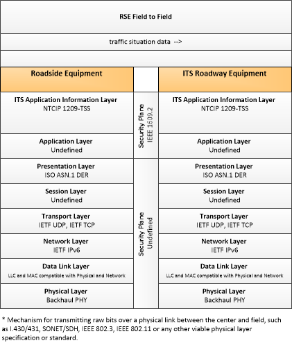
Link Type: Field to Field
Roadside Equipment --> ITS Roadway Equipment:
traffic situation data
Definitions
traffic situation data (Information Flow): Current, aggregate traffic data collected from connected vehicles that can be used to supplement or replace information collected by roadside traffic detectors. It includes raw and/or processed reported vehicle speeds, counts, and other derived measures. Raw and/or filtered vehicle control events may also be included to support incident detection.
Roadside Equipment (Source Physical Object): 'Roadside Equipment' (RSE) represents the Connected Vehicle roadside devices that are used to send messages to, and receive messages from, nearby vehicles using Dedicated Short Range Communications (DSRC) or other alternative wireless communications technologies. Communications with adjacent field equipment and back office centers that monitor and control the RSE are also supported. This device operates from a fixed position and may be permanently deployed or a portable device that is located temporarily in the vicinity of a traffic incident, road construction, or a special event. It includes a processor, data storage, and communications capabilities that support secure communications with passing vehicles, other field equipment, and centers.
ITS Roadway Equipment (Destination Physical Object): 'ITS Roadway Equipment' represents the ITS equipment that is distributed on and along the roadway that monitors and controls traffic and monitors and manages the roadway itself. In CVRIA, this physical object represents all of the other ITS field equipment that interfaces with and supports the Connected Vehicle Roadside Equipment (RSE). This physical object includes traffic detectors, environmental sensors, traffic signals, highway advisory radios, dynamic message signs, CCTV cameras and video image processing systems, grade crossing warning systems, and ramp metering systems. Lane management systems and barrier systems that control access to transportation infrastructure such as roadways, bridges and tunnels are also included. This object also provides environmental monitoring including sensors that measure road conditions, surface weather, and vehicle emissions. Work zone systems including work zone surveillance, traffic control, driver warning, and work crew safety systems are also included.
Included In
This Information Flow is in the following Applications:
- Cooperative Adaptive Cruise Control
- Eco-Cooperative Adaptive Cruise Control
- Eco-Ramp Metering
- Eco-Speed Harmonization
- Eco-Traffic Signal Timing
- Incident Scene Work Zone Alerts for Drivers and Workers
- Intelligent Traffic Signal System
- Queue Warning
- Roadside Lighting
- Speed Harmonization
- Stop Sign Gap Assist
- Variable Speed Limits for Weather-Responsive Traffic Management
- Warnings about Hazards in a Work Zone
This Information Flow is in the following Application Objects:
Communication Diagrams
The communication diagram(s) can be viewed in SVG or PNG format and the current format is SVG. Switch to PNG format.
Characteristics
Architectural:
| Characteristic | Value |
|---|---|
| Time Context | Recent |
| Spatial Context | Adjacent |
| Acknowledgement | False |
| Cardinality | Unicast |
| Initiator | Source |
Security
This information flow triple is in the following applications with the following security levels.
| Information Flow Security | |||||
|---|---|---|---|---|---|
| Application | Confidentiality | Integrity | Availability | ||
| Basis | Basis | Basis | |||
| Incident Scene Work Zone Alerts for Drivers and Workers | Not Applicable | Moderate | Moderate | ||
| This is all directly observable data. | This information is used to help with incident detection. It should be verified to ensure that it is not incorrectly influencing this. | This information is used as supplemental information. It should operate correctly if not every single message is received. | |||