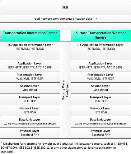
Link Type: Center to Center
Transportation Information Center --> Surface Transportation Weather Service:
road network environmental situation data
Definitions
road network environmental situation data (Information Flow): Aggregated environmental situation data collected from vehicles and other sources for the road network. Aggregated information would include measured air temperature, exterior light status, wiper status, sun sensor status, rain sensor status, traction control status, ALB status, and other collected vehicle system status and sensor information for the region.
Transportation Information Center (Source Physical Object): The 'Transportation Information Center' collects, processes, stores, and disseminates transportation information to system operators and the traveling public. The physical object can play several different roles in an integrated ITS. In one role, the TIC provides a data collection, fusing, and repackaging function, collecting information from transportation system operators and redistributing this information to other system operators in the region and other TICs. In this information redistribution role, the TIC provides a bridge between the various transportation systems that produce the information and the other TICs and their subscribers that use the information. The second role of a TIC is focused on delivery of traveler information to subscribers and the public at large. Information provided includes basic advisories, traffic and road conditions, transit schedule information, yellow pages information, ride matching information, and parking information. The TIC is commonly implemented as a website or a web-based application service, but it represents any traveler information distribution service.
Surface Transportation Weather Service (Destination Physical Object): The 'Surface Transportation Weather Service' represents the providers of value-added sector-specific meteorological services. These providers utilize National Weather Service data and predictions (including the qualified environmental data from the Clarus system), road condition information and local environmental data provided by traffic management or maintenance organizations, and their own models to provide surface transportation related weather observations and forecasts including pavement temperature and conditions.
Included In
This Information Flow is in the following Applications:
This Information Flow is in the following Application Objects:
Communication Diagrams
The communication diagram(s) can be viewed in SVG or PNG format and the current format is SVG. Switch to PNG format.
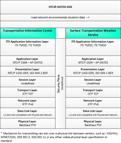
This profile describes an alternative set of standards applicable to communications between entities using ISO TC204 WG9 DATa Exchange(DATEX). Information messages are encoded using the NTCIP Octet Encoding Rules (OER).
Characteristics
Architectural:
| Characteristic | Value |
|---|---|
| Time Context | Recent |
| Spatial Context | Regional |
| Acknowledgement | True |
| Cardinality | Unicast |
| Initiator | Source |
Security
This information flow triple is in the following applications with the following security levels.
| Information Flow Security | |||||
|---|---|---|---|---|---|
| Application | Confidentiality | Integrity | Availability | ||
| Basis | Basis | Basis | |||
| Security levels have not been defined yet. | |||||