Link Type: Short Range Wireless
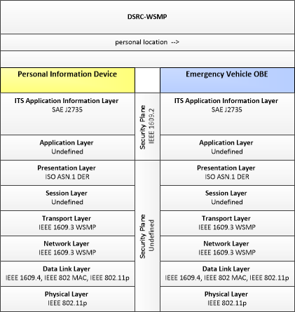
Personal Information Device --> Emergency Vehicle OBE:
personal location
Definitions
personal location (Information Flow): The current location (latitude, longitude, and elevation) reported by the personal information device
Personal Information Device (Source Physical Object): The 'Personal Information Device' provides the capability for travelers to receive formatted traveler information wherever they are. Capabilities include traveler information, trip planning, and route guidance. Frequently a smart phone, the Personal Information Device provides travelers with the capability to receive route planning and other personally focused transportation services from the infrastructure in the field, at home, at work, or while en-route. Personal Information Devices may operate independently or may be linked with connected vehicle on-board equipment.
Emergency Vehicle OBE (Destination Physical Object): The Emergency Vehicle On-Board Equipment (OBE) resides in an emergency vehicle and provides the processing, storage, and communications functions that support public safety-related connected vehicle applications. It represents a range of vehicles including those operated by police, fire, and emergency medical services. In addition, it represents other incident response vehicles including towing and recovery vehicles and freeway service patrols. It includes two-way communications to support coordinated response to emergencies. In CVRIA, a separate 'Vehicle OBE' physical object supports the general V2V and V2I safety applications and other applications that apply to all vehicles, including emergency vehicles. The Emergency Vehicle OBE supplements these general capabilities with capabilities that are specific to emergency vehicles.
Included In
This Information Flow is in the following Applications:
This Information Flow is in the following Application Objects:
Communication Diagrams
The communication diagram(s) can be viewed in SVG or PNG format and the current format is SVG. Switch to PNG format.
Characteristics
Architectural:
| Characteristic | Value |
|---|---|
| Time Context | Recent |
| Spatial Context | Adjacent |
| Acknowledgement | False |
| Cardinality | Broadcast |
| Initiator | Source |
Security
This information flow triple is in the following applications with the following security levels.
| Information Flow Security | |||||
|---|---|---|---|---|---|
| Application | Confidentiality | Integrity | Availability | ||
| Basis | Basis | Basis | |||
| Incident Scene Work Zone Alerts for Drivers and Workers | Not Applicable | High | Moderate | ||
| This data is intentionally transmitted to everyone via a broadcast. It can also be determined via other visual indicators. | As long as the emergency personnel stays within the geofenced area, it should not matter if this information is accurate. However, an incorrect locations message, saying that the person is outside of the geofenced area, could lead to a false warning. If they were actively helping a person, and then received a notification about an imminent collision because their location was inaccurate, it could lead to worse conditions for the person they're helping. | There are other visual indicators about the geofenced areas. Emergency personnel should know when they are leaving a geofenced area. As long as they remain in the geofenced area, this information is not as necessary. Additionally, not all emergency personnel may have this, and they should still be protected. | |||