Link Type: Wide-Area Wireless
Emergency Management Center --> Emergency Vehicle OBE:
decision support information
Definitions
decision support information (Information Flow): Information provided to support effective and safe incident response, including local traffic, road, and weather conditions, hazardous material information, and the current status of resources (including vehicles, other equipment, supplies) that have been allocated to an incident.
Emergency Management Center (Source Physical Object): The 'Emergency Management Center' represents systems that support incident management, disaster response and evacuation, security monitoring, and other security and public safety-oriented ITS applications. It includes the functions associated with fixed and mobile public safety communications centers including public safety call taker and dispatch centers operated by police (including transit police), fire, and emergency medical services. It includes the functions associated with Emergency Operations Centers that are activated at local, regional, state, and federal levels for emergencies and the portable and transportable systems that support Incident Command System operations at an incident. This Center also represents systems associated with towing and recovery, freeway service patrols, HAZMAT response teams, and mayday service providers.
It manages sensor and surveillance equipment used to enhance transportation security of the roadway infrastructure (including bridges, tunnels, interchanges, and other key roadway segments) and the public transportation system (including transit vehicles, public areas such as transit stops and stations, facilities such as transit yards, and transit infrastructure such as rail, bridges, tunnels, or bus guideways). It provides security/surveillance services to improve traveler security in public areas not a part of the public transportation system.
It monitors alerts, advisories, and other threat information and prepares for and responds to identified emergencies. It coordinates emergency response involving multiple agencies with peer centers. It stores, coordinates, and utilizes emergency response and evacuation plans to facilitate this coordinated response. Emergency situation information including damage assessments, response status, evacuation information, and resource information are shared The Emergency Management Center also provides a focal point for coordination of the emergency and evacuation information that is provided to the traveling public, including wide-area alerts when immediate public notification is warranted.
It tracks and manages emergency vehicle fleets using real-time road network status and routing information from the other centers to aid in selecting the emergency vehicle(s) and routes, and works with other relevant centers to tailor traffic control to support emergency vehicle ingress and egress, implementation of special traffic restrictions and closures, evacuation traffic control plans, and other special strategies that adapt the transportation system to better meet the unique demands of an emergency.
Emergency Vehicle OBE (Destination Physical Object): The Emergency Vehicle On-Board Equipment (OBE) resides in an emergency vehicle and provides the processing, storage, and communications functions that support public safety-related connected vehicle applications. It represents a range of vehicles including those operated by police, fire, and emergency medical services. In addition, it represents other incident response vehicles including towing and recovery vehicles and freeway service patrols. It includes two-way communications to support coordinated response to emergencies. In CVRIA, a separate 'Vehicle OBE' physical object supports the general V2V and V2I safety applications and other applications that apply to all vehicles, including emergency vehicles. The Emergency Vehicle OBE supplements these general capabilities with capabilities that are specific to emergency vehicles.
Included In
This Information Flow is in the following Applications:
- Incident Scene Pre-Arrival Staging Guidance for Emergency Responders
- Incident Scene Work Zone Alerts for Drivers and Workers
This Information Flow is in the following Application Objects:
Communication Diagrams
The communication diagram(s) can be viewed in SVG or PNG format and the current format is SVG. Switch to PNG format.
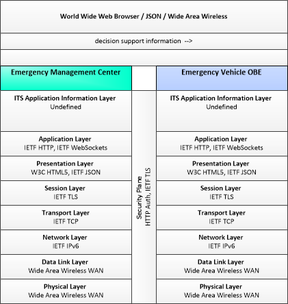
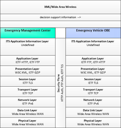
This profile describes applicable XML and W3C web services standards used in transmissions over wide area wireless communications.
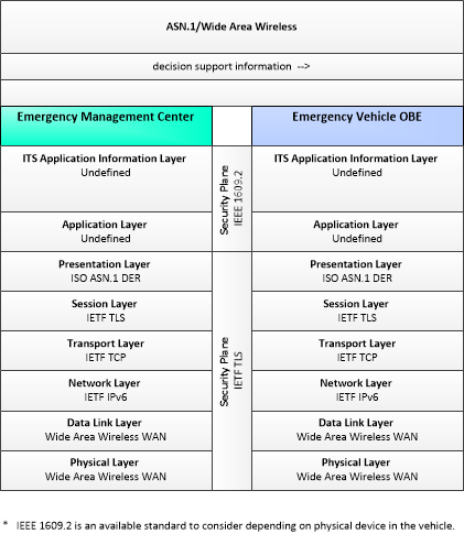
This profile describes applicable ASN.1 standards used in transmissions over wide area wireless communications.
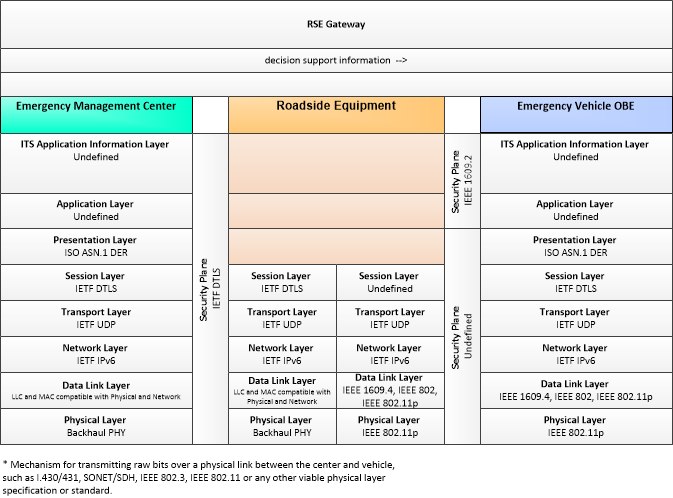
This profile describes an alternative set of standards used in vehicle communications where one or more RSEs act as a gateway with the vehicle as destination.
Characteristics
Architectural:
| Characteristic | Value |
|---|---|
| Time Context | Recent |
| Spatial Context | Regional |
| Acknowledgement | True |
| Cardinality | Unicast |
| Initiator | Destination |
Security
This information flow triple is in the following applications with the following security levels.
| Information Flow Security | |||||
|---|---|---|---|---|---|
| Application | Confidentiality | Integrity | Availability | ||
| Basis | Basis | Basis | |||
| Incident Scene Work Zone Alerts for Drivers and Workers | Moderate | Moderate | Moderate | ||
| This information could be of interest to a malicious individual who is attempting to determine the best way to accomplish a crime. As such it would be best to not make it easily accessible. | If this is compromised, it could send inaccurate information to a vehicle which could lead to inappropriate actions in the incident area. | A delay in reporting this may cause a delay in response or inability for an Emergency Vehicle and its personnel to properly respond to the incident. | |||