Link Type: Center to Field
Emergency Management Center --> ITS Roadway Equipment:
work zone warning device control
Definitions
work zone warning device control (Information Flow): Data used to configure and control work zone safety monitoring and warning devices.
Emergency Management Center (Source Physical Object): The 'Emergency Management Center' represents systems that support incident management, disaster response and evacuation, security monitoring, and other security and public safety-oriented ITS applications. It includes the functions associated with fixed and mobile public safety communications centers including public safety call taker and dispatch centers operated by police (including transit police), fire, and emergency medical services. It includes the functions associated with Emergency Operations Centers that are activated at local, regional, state, and federal levels for emergencies and the portable and transportable systems that support Incident Command System operations at an incident. This Center also represents systems associated with towing and recovery, freeway service patrols, HAZMAT response teams, and mayday service providers.
It manages sensor and surveillance equipment used to enhance transportation security of the roadway infrastructure (including bridges, tunnels, interchanges, and other key roadway segments) and the public transportation system (including transit vehicles, public areas such as transit stops and stations, facilities such as transit yards, and transit infrastructure such as rail, bridges, tunnels, or bus guideways). It provides security/surveillance services to improve traveler security in public areas not a part of the public transportation system.
It monitors alerts, advisories, and other threat information and prepares for and responds to identified emergencies. It coordinates emergency response involving multiple agencies with peer centers. It stores, coordinates, and utilizes emergency response and evacuation plans to facilitate this coordinated response. Emergency situation information including damage assessments, response status, evacuation information, and resource information are shared The Emergency Management Center also provides a focal point for coordination of the emergency and evacuation information that is provided to the traveling public, including wide-area alerts when immediate public notification is warranted.
It tracks and manages emergency vehicle fleets using real-time road network status and routing information from the other centers to aid in selecting the emergency vehicle(s) and routes, and works with other relevant centers to tailor traffic control to support emergency vehicle ingress and egress, implementation of special traffic restrictions and closures, evacuation traffic control plans, and other special strategies that adapt the transportation system to better meet the unique demands of an emergency.
ITS Roadway Equipment (Destination Physical Object): 'ITS Roadway Equipment' represents the ITS equipment that is distributed on and along the roadway that monitors and controls traffic and monitors and manages the roadway itself. In CVRIA, this physical object represents all of the other ITS field equipment that interfaces with and supports the Connected Vehicle Roadside Equipment (RSE). This physical object includes traffic detectors, environmental sensors, traffic signals, highway advisory radios, dynamic message signs, CCTV cameras and video image processing systems, grade crossing warning systems, and ramp metering systems. Lane management systems and barrier systems that control access to transportation infrastructure such as roadways, bridges and tunnels are also included. This object also provides environmental monitoring including sensors that measure road conditions, surface weather, and vehicle emissions. Work zone systems including work zone surveillance, traffic control, driver warning, and work crew safety systems are also included.
Included In
This Information Flow is in the following Applications:
This Information Flow is in the following Application Objects:
Communication Diagrams
The communication diagram(s) can be viewed in SVG or PNG format and the current format is SVG. Switch to PNG format.
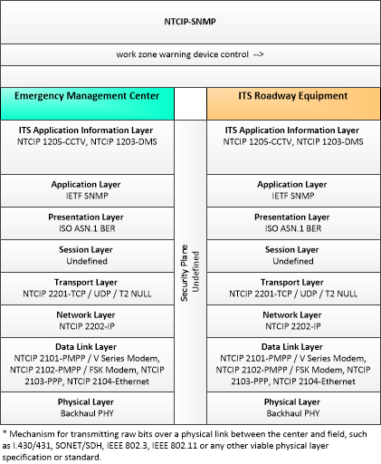
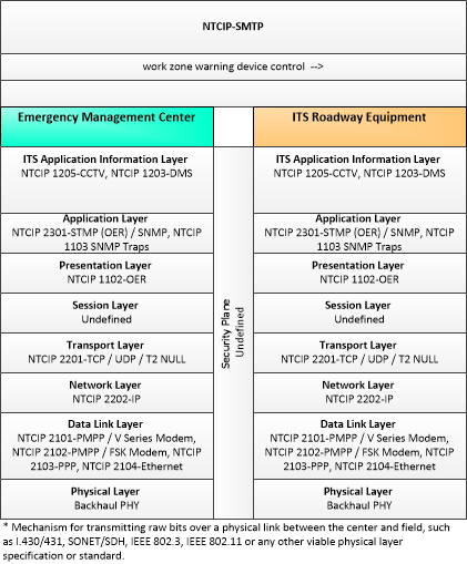
This profile describes an alternative set of standards used to communicate with ITS Roadway Devices that uses the NTCIP Octet Encoding Rules (OER), a standard developed specifically for the transportation industry. This template is used primarily for communication with traffic signal controllers, where second-per-second communications is required. This template also includes standards for SNMP traps, that allows an ITS Roadway Device to initiate event-driven communications with a receiver.
Characteristics
Architectural:
| Characteristic | Value |
|---|---|
| Time Context | Recent |
| Spatial Context | Local |
| Acknowledgement | True |
| Cardinality | Unicast |
| Initiator | Source |
Security
This information flow triple is in the following applications with the following security levels.
| Information Flow Security | |||||
|---|---|---|---|---|---|
| Application | Confidentiality | Integrity | Availability | ||
| Basis | Basis | Basis | |||
| Incident Scene Work Zone Alerts for Drivers and Workers | Moderate | Moderate | Low | ||
| This data has the potential to be useful to people with criminal intent, because knowing how emergency vehicles will respond to an incident could be abused. Knowing this information will not directly harm anyone. This may additionally contain sensitive data determined by the supplier (for example, because this flow contains proprietary or security-sensitive information about the device). | This is the configuration data for the device, it should be accurate, but the device should not accept a configuration that would lead to catastrophic failure. | The ITS RE should be reasonably configured already. This means there receiving of configuration is not time sensitive. The EMC should know if a configuration was successfully applied. | |||