Link Type: Wide-Area Wireless
Map Update System --> Personal Information Device:
intersection geometry
Definitions
intersection geometry (Information Flow): The physical geometry of an intersection covering the location and width of each approaching lane, egress lane, and valid paths between approaches and egresses. This flow also defines the location of stop lines, cross walks, specific traffic law restrictions for the intersection (e.g., turning movement restrictions), and other elements that support calculation of a safe and legal vehicle path through the intersection.
Map Update System (Source Physical Object): The 'Map Update System' represents a provider of map databases used to support ITS services. It supports the provision of the map data that are used directly by vehicles (e.g., roadway and intersection geometry data sets), travelers (e.g., navigable maps used for route guidance and display maps used at traveler information points), system operators (e.g., map data used by Traffic Operators to monitor and manage the road network, and map data used by Fleet Managers to manage a vehicle fleet). It may represent a third-party provider or an internal organization that produces map data for agency use. Products may include simple display maps, map data sets that define detailed road network topology and geometry, or full geographic information system databases that are used to support planning and operations.
Personal Information Device (Destination Physical Object): The 'Personal Information Device' provides the capability for travelers to receive formatted traveler information wherever they are. Capabilities include traveler information, trip planning, and route guidance. Frequently a smart phone, the Personal Information Device provides travelers with the capability to receive route planning and other personally focused transportation services from the infrastructure in the field, at home, at work, or while en-route. Personal Information Devices may operate independently or may be linked with connected vehicle on-board equipment.
Included In
This Information Flow is in the following Applications:
This Information Flow is in the following Application Objects:
Communication Diagrams
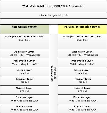
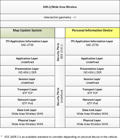
The communication diagram(s) can be viewed in SVG or PNG format and the current format is SVG. Switch to PNG format.
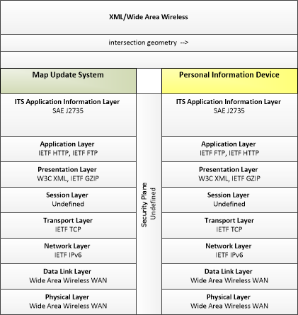
This profile describes applicable XML and W3C web services standards used in transmissions over wide area wireless communications.
This profile describes applicable ASN.1 standards used in transmissions over wide area wireless communications.
Characteristics
Architectural:
| Characteristic | Value |
|---|---|
| Time Context | Recent |
| Spatial Context | Regional |
| Acknowledgement | False |
| Cardinality | Unicast |
| Initiator | Destination |
Security
This information flow triple is in the following applications with the following security levels.
| Information Flow Security | |||||
|---|---|---|---|---|---|
| Application | Confidentiality | Integrity | Availability | ||
| Basis | Basis | Basis | |||
| Security levels have not been defined yet. | |||||