Link Type: Wide-Area Wireless
Map Update System --> Vehicle OBE:
roadway geometry
Definitions
roadway geometry (Information Flow): The physical geometry of a road segment that specifies the location and width of each lane, including normal lanes as well as special lanes for pedestrians and bicycles, transit vehicles, and trains. This flow also may include the curvature, grade, and superelevation or banking of the road segment.
Map Update System (Source Physical Object): The 'Map Update System' represents a provider of map databases used to support ITS services. It supports the provision of the map data that are used directly by vehicles (e.g., roadway and intersection geometry data sets), travelers (e.g., navigable maps used for route guidance and display maps used at traveler information points), system operators (e.g., map data used by Traffic Operators to monitor and manage the road network, and map data used by Fleet Managers to manage a vehicle fleet). It may represent a third-party provider or an internal organization that produces map data for agency use. Products may include simple display maps, map data sets that define detailed road network topology and geometry, or full geographic information system databases that are used to support planning and operations.
Vehicle OBE (Destination Physical Object): The Vehicle On-Board Equipment (OBE) provides the vehicle-based processing, storage, and communications functions necessary to support connected vehicle operations. The radio(s) supporting V2V and V2I communications are a key component of the Vehicle OBE. This communication platform is augmented with processing and data storage capability that supports the connected vehicle applications.
In CVRIA, the Vehicle OBE includes the functions and interfaces that support connected vehicle applications for passenger cars, trucks, and motorcycles. Many of these applications (e.g., V2V Safety applications) apply to all vehicle types including personal vehicles, commercial vehicles, emergency vehicles, transit vehicles, and maintenance vehicles. From this perspective, the Vehicle OBE includes the common interfaces and functions that apply to all motorized vehicles.
Included In
This Information Flow is in the following Applications:
This Information Flow is in the following Application Objects:
Communication Diagrams
The communication diagram(s) can be viewed in SVG or PNG format and the current format is SVG. Switch to PNG format.
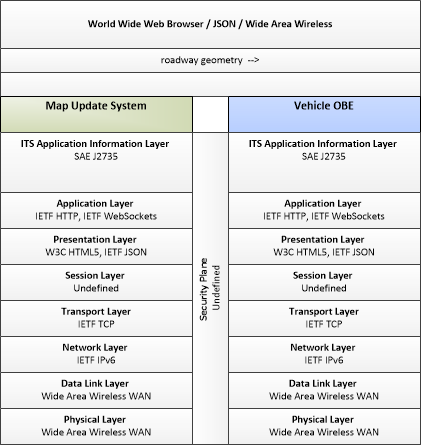
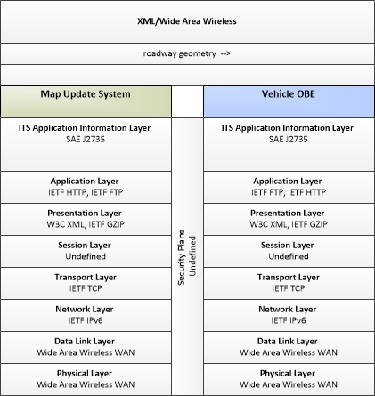
This profile describes applicable XML and W3C web services standards used in transmissions over wide area wireless communications.
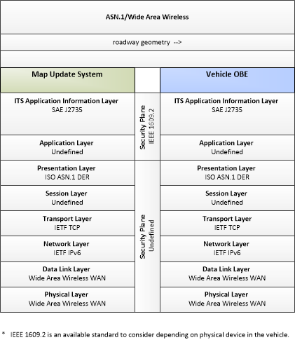
This profile describes applicable ASN.1 standards used in transmissions over wide area wireless communications.
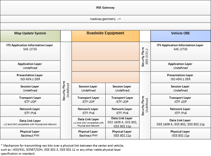
This profile describes an alternative set of standards used in vehicle communications where one or more RSEs act as a gateway with the vehicle as destination.
Characteristics
Architectural:
| Characteristic | Value |
|---|---|
| Time Context | Recent |
| Spatial Context | Regional |
| Acknowledgement | False |
| Cardinality | Unicast |
| Initiator | Destination |
Security
This information flow triple is in the following applications with the following security levels.
| Information Flow Security | |||||
|---|---|---|---|---|---|
| Application | Confidentiality | Integrity | Availability | ||
| Basis | Basis | Basis | |||
| Security levels have not been defined yet. | |||||