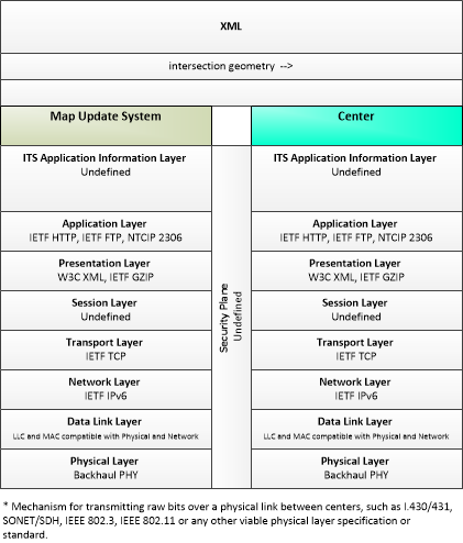
Link Type: Center to Center
Map Update System --> Center:
intersection geometry
Definitions
intersection geometry (Information Flow): The physical geometry of an intersection covering the location and width of each approaching lane, egress lane, and valid paths between approaches and egresses. This flow also defines the location of stop lines, cross walks, specific traffic law restrictions for the intersection (e.g., turning movement restrictions), and other elements that support calculation of a safe and legal vehicle path through the intersection.
Map Update System (Source Physical Object): The 'Map Update System' represents a provider of map databases used to support ITS services. It supports the provision of the map data that are used directly by vehicles (e.g., roadway and intersection geometry data sets), travelers (e.g., navigable maps used for route guidance and display maps used at traveler information points), system operators (e.g., map data used by Traffic Operators to monitor and manage the road network, and map data used by Fleet Managers to manage a vehicle fleet). It may represent a third-party provider or an internal organization that produces map data for agency use. Products may include simple display maps, map data sets that define detailed road network topology and geometry, or full geographic information system databases that are used to support planning and operations.
Center (Destination Physical Object): This general physical object is used to model core capabilities that are common to any center.
Included In
This Information Flow is in the following Applications:
This Information Flow is in the following Application Objects:
Communication Diagrams
The communication diagram(s) can be viewed in SVG or PNG format and the current format is SVG. Switch to PNG format.
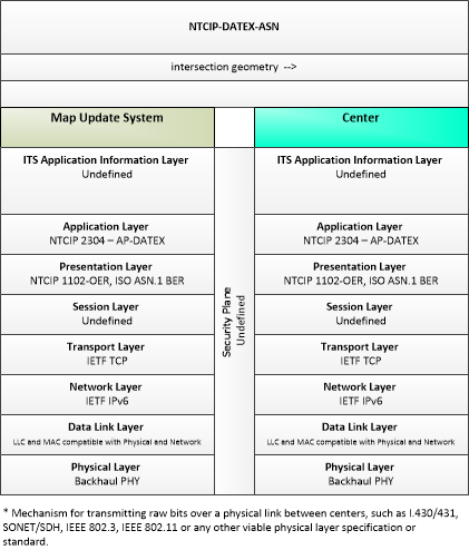
This profile describes an alternative set of standards applicable to communications between entities using ISO TC204 WG9 DATa Exchange(DATEX). Information messages are encoded using the NTCIP Octet Encoding Rules (OER).
Characteristics
Architectural:
| Characteristic | Value |
|---|---|
| Time Context | Recent |
| Spatial Context | Regional |
| Acknowledgement | False |
| Cardinality | Unicast |
| Initiator | Destination |
Security
This information flow triple is in the following applications with the following security levels.
| Information Flow Security | |||||
|---|---|---|---|---|---|
| Application | Confidentiality | Integrity | Availability | ||
| Basis | Basis | Basis | |||
| Security levels have not been defined yet. | |||||