Link Type: Center to Center
Parking Management System --> Map Update System:
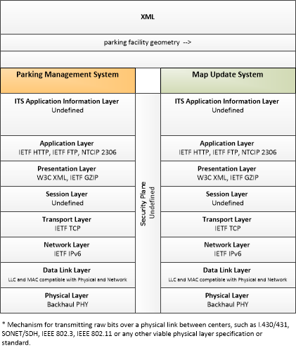
parking facility geometry
This triple is bi-directional. See also
Map Update System --> Parking Management System: parking facility geometry
Definitions
parking facility geometry (Information Flow): Precise spatial description of a parking facility that locates each parking space and the ingress and egress routes that are used to travel to and from the spaces.
Parking Management System (Source Physical Object): The Parking Management System provides electronic monitoring and management of parking facilities. It supports an I2V link to the Vehicle that allows electronic collection of parking fees and monitors and controls parking meters that support conventional parking fee collection. It also includes the instrumentation, signs, and other infrastructure that monitors parking lot usage and provides local information about parking availability and other general parking information. This portion of the functionality must be located in the parking facility where it can monitor, classify, and share information with customers and their vehicles. It also interfaces with the financial infrastructure and broadly disseminates parking information to other operational centers in the region. Note that the latter functionality may be located in a back office, remote from the parking facility.
Map Update System (Destination Physical Object): The 'Map Update System' represents a provider of map databases used to support ITS services. It supports the provision of the map data that are used directly by vehicles (e.g., roadway and intersection geometry data sets), travelers (e.g., navigable maps used for route guidance and display maps used at traveler information points), system operators (e.g., map data used by Traffic Operators to monitor and manage the road network, and map data used by Fleet Managers to manage a vehicle fleet). It may represent a third-party provider or an internal organization that produces map data for agency use. Products may include simple display maps, map data sets that define detailed road network topology and geometry, or full geographic information system databases that are used to support planning and operations.
Included In
This Information Flow is in the following Applications:
This Information Flow is in the following Application Objects:
Communication Diagrams
The communication diagram(s) can be viewed in SVG or PNG format and the current format is SVG. Switch to PNG format.
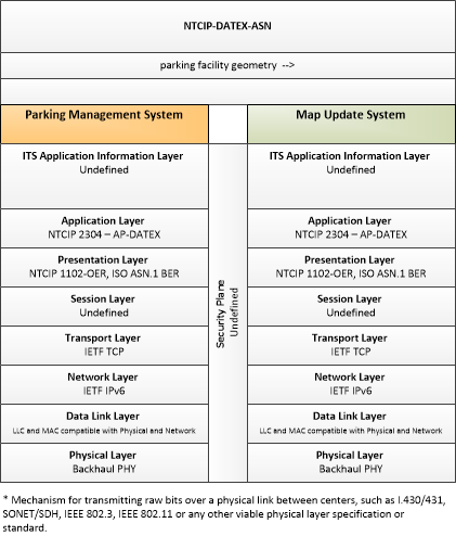
This profile describes an alternative set of standards applicable to communications between entities using ISO TC204 WG9 DATa Exchange(DATEX). Information messages are encoded using the NTCIP Octet Encoding Rules (OER).
Characteristics
Architectural:
| Characteristic | Value |
|---|---|
| Time Context | Recent |
| Spatial Context | Regional |
| Acknowledgement | False |
| Cardinality | Unicast |
| Initiator | Source |
Security
This information flow triple is in the following applications with the following security levels.
| Information Flow Security | |||||
|---|---|---|---|---|---|
| Application | Confidentiality | Integrity | Availability | ||
| Basis | Basis | Basis | |||
| Security levels have not been defined yet. | |||||