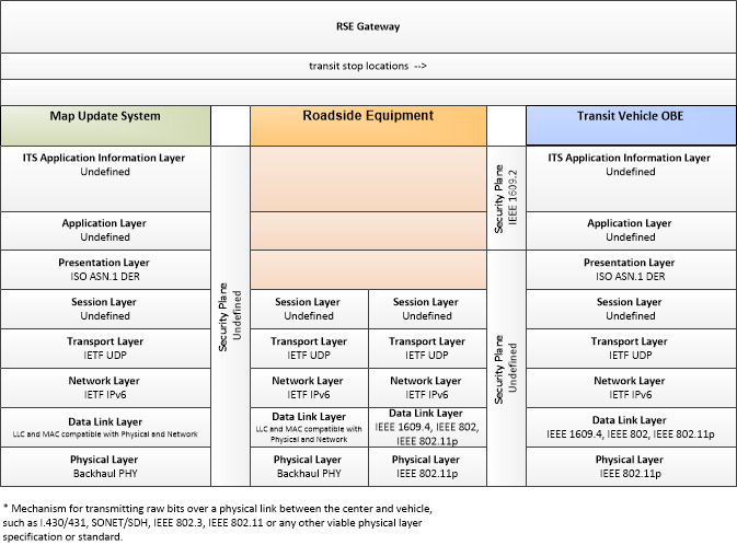
Link Type: Wide-Area Wireless
Map Update System --> Transit Vehicle OBE:
transit stop locations
Definitions
transit stop locations (Information Flow): The current geographic location and dimensions of transit stops. This flow may also include the road geometry in the vicinity of the stops as needed to support transit vehicle safety applications when arriving at or departing from stops.
Map Update System (Source Physical Object): The 'Map Update System' represents a provider of map databases used to support ITS services. It supports the provision of the map data that are used directly by vehicles (e.g., roadway and intersection geometry data sets), travelers (e.g., navigable maps used for route guidance and display maps used at traveler information points), system operators (e.g., map data used by Traffic Operators to monitor and manage the road network, and map data used by Fleet Managers to manage a vehicle fleet). It may represent a third-party provider or an internal organization that produces map data for agency use. Products may include simple display maps, map data sets that define detailed road network topology and geometry, or full geographic information system databases that are used to support planning and operations.
Transit Vehicle OBE (Destination Physical Object): The Transit Vehicle On-Board equipment (OBE) resides in a transit vehicle and provides the sensory, processing, storage, and communications functions necessary to support safe and efficient movement of passengers. The types of transit vehicles containing this physical object include buses, paratransit vehicles, light rail vehicles, other vehicles designed to carry passengers, and supervisory vehicles. It collects ridership levels and supports electronic fare collection. It supports a traffic signal prioritization function that communicates with the roadside physical object to improve on-schedule performance. Automated vehicle location enhances the information available to the transit operator enabling more efficient operations. On-board sensors support transit vehicle maintenance. The physical object supports on-board security and safety monitoring. This monitoring includes transit user or vehicle operator activated alarms (silent or audible), as well as surveillance and sensor equipment. The surveillance equipment includes video (e.g. CCTV cameras), audio systems and/or event recorder systems. It also furnishes travelers with real-time travel information, continuously updated schedules, transfer options, routes, and fares. In CVRIA, a separate 'Vehicle OBE' physical object supports the general V2V and V2I safety applications and other applications that apply to all vehicles, including transit vehicles. The Transit Vehicle OBE supplements these general capabilities with capabilities that are specific to transit vehicles.
Included In
This Information Flow is in the following Applications:
This Information Flow is in the following Application Objects:
Communication Diagrams
The communication diagram(s) can be viewed in SVG or PNG format and the current format is SVG. Switch to PNG format.
This profile describes applicable XML and W3C web services standards used in transmissions over wide area wireless communications.
This profile describes applicable ASN.1 standards used in transmissions over wide area wireless communications.
This profile describes an alternative set of standards used in vehicle communications where one or more RSEs act as a gateway with the vehicle as destination.
Characteristics
Architectural:
| Characteristic | Value |
|---|---|
| Time Context | Recent |
| Spatial Context | Regional |
| Acknowledgement | False |
| Cardinality | Unicast |
| Initiator | Destination |
Security
This information flow triple is in the following applications with the following security levels.
| Information Flow Security | |||||
|---|---|---|---|---|---|
| Application | Confidentiality | Integrity | Availability | ||
| Basis | Basis | Basis | |||
| Security levels have not been defined yet. | |||||


