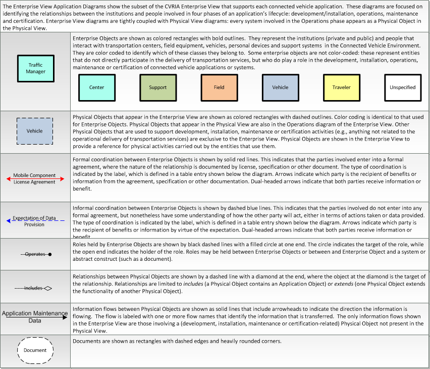
Type: Support
Groups:- Core Services
Map Management
The Map Management application defines interfaces that can be used download or update all types of map data used to support connected vehicle applications. This map data will be accessed by centers, field, and vehicle physical objects. The application can be used to harness the Connected Vehicle Environment to provide rich source data that can be used to verify, refine, and enhance geographic map data.
Enterprise
This is one way this application may be realized, but not the only way. There are other ways to build a given application and accomplish a stated objective.
The enterprise diagram can be viewed in SVG or PNG format and the current format is SVG. SVG Diagram
PNG Diagram
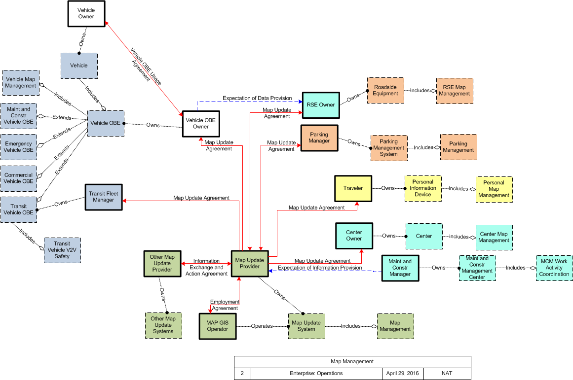
Business Interaction Matrix:
| Connected Vehicle Map Management Operations Stage | |||||||||||
|---|---|---|---|---|---|---|---|---|---|---|---|
| Vehicle Owner | Vehicle OBE Owner | RSE Owner | Maint and Constr Manager | Map Update Provider | Traveler | Transit Fleet Manager | Parking Manager | Center Owner | MAP GIS Operator | Other Map Update Provider | |
| Vehicle Owner | Vehicle OBE Usage Agreement | ||||||||||
| Vehicle OBE Owner | Vehicle OBE Usage Agreement | Expectation of Data Provision | Map Update Agreement | ||||||||
| RSE Owner | Expectation of Data Provision | Map Update Agreement | |||||||||
| Maint and Constr Manager | Expectation of Information Provision | ||||||||||
| Map Update Provider | Map Update Agreement | Map Update Agreement | Expectation of Information Provision | Map Update Agreement | Map Update Agreement | Map Update Agreement | Map Update Agreement | Employment Agreement | Information Exchange and Action Agreement | ||
| Traveler | Map Update Agreement | ||||||||||
| Transit Fleet Manager | Map Update Agreement | ||||||||||
| Parking Manager | Map Update Agreement | ||||||||||
| Center Owner | Map Update Agreement | ||||||||||
| MAP GIS Operator | Employment Agreement | ||||||||||
| Other Map Update Provider | Information Exchange and Action Agreement | ||||||||||
Includes Enterprise Objects:
| Enterprise Object | Description |
|---|---|
| Center Owner | General representation of the owner of the general "Center" physical object. |
| Maint and Constr Manager | The organization responsible for maintenance and construction activities. |
| MAP GIS Operator | The 'Map GIS Operator' represents the person or people that manage GIS updates, supporting import and translation of source data, preparing the base map and information layers, and providing oversight and management for incremental releases of updated map data. |
| Map Update Provider | The entity that provides the initial and updates to maps used by connected vehicle environment devices. |
| Other Map Update Provider | Another entity that provides the initial and updates to maps used by connected vehicle environment devices. |
| Parking Manager | The organization that manages parking facilities, including lots, access control, parking meters. |
| RSE Owner | The owner of roadside equipment. |
| Transit Fleet Manager | The agency or organization that operates transit vehicles. This includes administration, routing, driver instruction, maintenance and any other responsibilities associated with the operations and maintenance of a transit system. |
| Traveler | The 'Traveler' represents any individual who uses transportation services. The interfaces to the traveler provide general pre-trip and en-route information supporting trip planning, personal guidance, and requests for assistance in an emergency that are relevant to all transportation system users. It also represents users of a public transportation system and addresses interfaces these users have within a transit vehicle or at transit facilities such as roadside stops and transit centers. |
| Vehicle OBE Owner | The entity, individual, group or corporation that owns the Vehicle On-Board equipment. This could be the same as the Vehicle Owner, but it could be a third part that licenses the use of the OBE to the Owner. |
| Vehicle Owner | The individual, group of individuals or corporate entity that is identified as the registered owner of the Vehicle under state law. |
Includes Resources:
| Resource | Description |
|---|---|
| Center | This general physical object is used to model core capabilities that are common to any center. |
| Center Map Management | "Center Map Management" provides the map functionality necessary to support map updates and use within an operational center. It manages map data for the center and provides map data to center applications that use a map. |
| Commercial Vehicle OBE | The Commercial Vehicle On-Board Equipment (OBE) resides in a commercial vehicle and provides the sensory, processing, storage, and communications functions necessary to support safe and efficient commercial vehicle operations. It provides two-way communications between the commercial vehicle drivers, their fleet managers, attached freight equipment, and roadside officials. In CVRIA, a separate 'Vehicle OBE' physical object supports the general V2V and V2I safety applications and other applications that apply to all vehicles, including commercial vehicles. The Commercial Vehicle OBE supplements these general capabilities with capabilities that are specific to commercial vehicles. |
| Emergency Vehicle OBE | The Emergency Vehicle On-Board Equipment (OBE) resides in an emergency vehicle and provides the processing, storage, and communications functions that support public safety-related connected vehicle applications. It represents a range of vehicles including those operated by police, fire, and emergency medical services. In addition, it represents other incident response vehicles including towing and recovery vehicles and freeway service patrols. It includes two-way communications to support coordinated response to emergencies. In CVRIA, a separate 'Vehicle OBE' physical object supports the general V2V and V2I safety applications and other applications that apply to all vehicles, including emergency vehicles. The Emergency Vehicle OBE supplements these general capabilities with capabilities that are specific to emergency vehicles. |
| Maint and Constr Management Center | The 'Maint and Constr Management Center' monitors and manages roadway infrastructure construction and maintenance activities. Representing both public agencies and private contractors that provide these functions, this physical object manages fleets of maintenance, construction, or special service vehicles (e.g., snow and ice control equipment). The physical object receives a wide range of status information from these vehicles and performs vehicle dispatch, routing, and resource management for the vehicle fleets and associated equipment. The physical object participates in incident response by deploying maintenance and construction resources to an incident scene, in coordination with other center physical objects. The physical object manages equipment at the roadside, including environmental sensors and automated systems that monitor and mitigate adverse road and surface weather conditions. It manages the repair and maintenance of both non-ITS and ITS equipment including the traffic controllers, detectors, dynamic message signs, signals, and other equipment associated with the roadway infrastructure. Weather information is collected and fused with other data sources and used to support advanced decision support systems. The physical object remotely monitors and manages ITS capabilities in work zones, gathering, storing, and disseminating work zone information to other systems. It manages traffic in the vicinity of the work zone and advises drivers of work zone status (either directly at the roadside or through an interface with the Transportation Information Center or Traffic Management Center physical objects.) Construction and maintenance activities are tracked and coordinated with other systems, improving the quality and accuracy of information available regarding closures and other roadway construction and maintenance activities. |
| Maint and Constr Vehicle OBE | The 'Maint and Constr Vehicle OBE' resides in a maintenance, construction, or other specialized service vehicle or equipment and provides the processing, storage, and communications functions necessary to support highway maintenance and construction. All types of maintenance and construction vehicles are covered, including heavy equipment and supervisory vehicles. The MCV OBE provides two-way communications between drivers/operators and dispatchers and maintains and communicates current location and status information. A wide range of operational status is monitored, measured, and made available, depending on the specific type of vehicle or equipment. A snow plow for example, would monitor whether the plow is up or down and material usage information. The Maint and Constr Vehicle OBE may also contain capabilities to monitor vehicle systems to support maintenance of the vehicle itself and include sensors that monitor environmental conditions such as road condition and surface weather information. This can include a diverse set of mobile environmental sensing platforms, including wheeled vehicles and any other vehicle that collects and reports environmental information. In CVRIA, a separate 'Vehicle OBE' physical object supports the general V2V and V2I safety applications and other applications that apply to all vehicles, including maintenance and construction vehicles. The Maint and Constr Vehicle OBE supplements these general applications with applications that are specific to maintenance and construction vehicles. |
| Map Management | "Map Management" provides the GIS functionality necessary to support map data creation and management. It provides an operator interface that supports management of the map data and rendering of the maps under operator control and interfaces to external data sources, including the connected vehicle environment. |
| Map Update System | The 'Map Update System' represents a provider of map databases used to support ITS services. It supports the provision of the map data that are used directly by vehicles (e.g., roadway and intersection geometry data sets), travelers (e.g., navigable maps used for route guidance and display maps used at traveler information points), system operators (e.g., map data used by Traffic Operators to monitor and manage the road network, and map data used by Fleet Managers to manage a vehicle fleet). It may represent a third-party provider or an internal organization that produces map data for agency use. Products may include simple display maps, map data sets that define detailed road network topology and geometry, or full geographic information system databases that are used to support planning and operations. |
| MCM Work Activity Coordination | "MCM Work Activity Coordination" disseminates work activity schedules and current asset restrictions to other agencies. Work schedules are coordinated with operating agencies, factoring in the needs and activities of other agencies and adjacent jurisdictions. Work schedules are also distributed to Transportation Information Centers for dissemination to the traveling public. |
| Other Map Update Systems | Representing other distinct Map Update Systems, this object is intended to provide a source and destination for ITS information flows between peer map update providers. It enables cooperative information sharing between base map and specialized map providers and any other exchange of geographic information between map data providers. |
| Parking Management | "Parking Management" detects and classifies vehicles at parking facility entrances, exits, and other designated locations within the facility. Current parking availability is monitored and used to inform drivers through dynamic message signs/displays so that vehicles are efficiently routed to available spaces. Parking facility information, including current parking rates and directions to entrances and available exits, is also provided to drivers. Coordination with traffic management supports local traffic control coordination in and around the parking facility. |
| Parking Management System | The Parking Management System provides electronic monitoring and management of parking facilities. It supports an I2V link to the Vehicle that allows electronic collection of parking fees and monitors and controls parking meters that support conventional parking fee collection. It also includes the instrumentation, signs, and other infrastructure that monitors parking lot usage and provides local information about parking availability and other general parking information. This portion of the functionality must be located in the parking facility where it can monitor, classify, and share information with customers and their vehicles. It also interfaces with the financial infrastructure and broadly disseminates parking information to other operational centers in the region. Note that the latter functionality may be located in a back office, remote from the parking facility. |
| Personal Information Device | The 'Personal Information Device' provides the capability for travelers to receive formatted traveler information wherever they are. Capabilities include traveler information, trip planning, and route guidance. Frequently a smart phone, the Personal Information Device provides travelers with the capability to receive route planning and other personally focused transportation services from the infrastructure in the field, at home, at work, or while en-route. Personal Information Devices may operate independently or may be linked with connected vehicle on-board equipment. |
| Personal Map Management | "Personal Map Management" supports map updates and makes current map and geometry data available to other applications. It manages map data for the device and provides map data to end-user applications that provide location-based services. |
| Roadside Equipment | 'Roadside Equipment' (RSE) represents the Connected Vehicle roadside devices that are used to send messages to, and receive messages from, nearby vehicles using Dedicated Short Range Communications (DSRC) or other alternative wireless communications technologies. Communications with adjacent field equipment and back office centers that monitor and control the RSE are also supported. This device operates from a fixed position and may be permanently deployed or a portable device that is located temporarily in the vicinity of a traffic incident, road construction, or a special event. It includes a processor, data storage, and communications capabilities that support secure communications with passing vehicles, other field equipment, and centers. |
| RSE Map Management | "RSE Map Management" provides the map functionality necessary to support map data updates to passing vehicles. It collects current map and geometry data and provides current map and geometry data to connected vehicles. |
| Transit Vehicle OBE | The Transit Vehicle On-Board equipment (OBE) resides in a transit vehicle and provides the sensory, processing, storage, and communications functions necessary to support safe and efficient movement of passengers. The types of transit vehicles containing this physical object include buses, paratransit vehicles, light rail vehicles, other vehicles designed to carry passengers, and supervisory vehicles. It collects ridership levels and supports electronic fare collection. It supports a traffic signal prioritization function that communicates with the roadside physical object to improve on-schedule performance. Automated vehicle location enhances the information available to the transit operator enabling more efficient operations. On-board sensors support transit vehicle maintenance. The physical object supports on-board security and safety monitoring. This monitoring includes transit user or vehicle operator activated alarms (silent or audible), as well as surveillance and sensor equipment. The surveillance equipment includes video (e.g. CCTV cameras), audio systems and/or event recorder systems. It also furnishes travelers with real-time travel information, continuously updated schedules, transfer options, routes, and fares. In CVRIA, a separate 'Vehicle OBE' physical object supports the general V2V and V2I safety applications and other applications that apply to all vehicles, including transit vehicles. The Transit Vehicle OBE supplements these general capabilities with capabilities that are specific to transit vehicles. |
| Transit Vehicle V2V Safety | "Transit Vehicle V2V Safety" exchanges current vehicle location and motion information with other vehicles in the vicinity, uses that information to predict vehicle paths, and notifies the driver when the potential for an impending collision is detected. Information from on-board sensors (e.g., radars and image processing) are used to augment the V2V communications, if available. In addition to notifying the driver, control information can also be provided to support automated control functions that can avoid the collision. This object is similar to the "Vehicle Basic V2V Safety", but it accounts for crash scenarios that are unique to transit vehicles (e.g., Vehicle Turning Right in Front of Bus). It is also stop-aware since stop locations pose specific crash threats for transit vehicles. Finally, the detection and control algorithms, filters, and timing account for bus performance and risk profiles associated with remote vehicles that are unique to transit. |
| Vehicle | The conveyance that provides the sensory, processing, storage, and communications functions necessary to support efficient, safe, and convenient travel. These functions reside in general vehicles including personal automobiles, commercial vehicles, emergency vehicles, transit vehicles, or other vehicle types. |
| Vehicle Map Management | "Vehicle Map Management" supports map updates and makes current map and geometry data available to other applications. It manages map data on-board and provides map data to end-user applications that provide location-based services. |
| Vehicle OBE | The Vehicle On-Board Equipment (OBE) provides the vehicle-based processing, storage, and communications functions necessary to support connected vehicle operations. The radio(s) supporting V2V and V2I communications are a key component of the Vehicle OBE. This communication platform is augmented with processing and data storage capability that supports the connected vehicle applications. In CVRIA, the Vehicle OBE includes the functions and interfaces that support connected vehicle applications for passenger cars, trucks, and motorcycles. Many of these applications (e.g., V2V Safety applications) apply to all vehicle types including personal vehicles, commercial vehicles, emergency vehicles, transit vehicles, and maintenance vehicles. From this perspective, the Vehicle OBE includes the common interfaces and functions that apply to all motorized vehicles. |
Includes Roles:
| Role | Description |
|---|---|
| Operates | An Enterprise controls the functionality and state of the target Resource. An Enterprise that Operates a resource is considered Responsible. |
| Owns | An Enterprise has financial ownership and control over the Resource. An Enterprise that Owns a resource is considered Accountable. |
Includes Coordination:
| Coordination | Type | Description |
|---|---|---|
| Employment Agreement | Agreement | An agreement between an individual and a corporation or government entity, whereupon the individual agrees to provide labor to the corporation/agency, which in turn compensates the employee. Stipulates level of compensation, working conditions, necessary equipment and training and expectations of employee performance. |
| Expectation of Data Provision | Expectation | An expectation where one party believes another party will provide data on a regular and recurring basis, and that that data will be useful to the receiver in the context of the receiver's application. This thus includes some expectation of data fields, timeliness, quality, precision and similar qualities of data. |
| Expectation of Information Provision | Expectation | An expectation where one party believes another party will provide it information whenever such information is likely relevant to the recipient. |
| Extends | Includes | Indicates that one component includes all of the functionality of another component, and in provides additional functionality beyond that other component's. |
| Includes | Includes | Indicates that one component is entirely contained within another component. |
| Information Exchange and Action Agreement | Agreement | An agreement to exchange information, which may include data or control information; the exact information to be exchanged may vary from agreement to agreement. This also includes a specification for action that shall, should or may be taken by one party in response to this information. |
| Map Update Agreement | Agreement | An agreement whereupon one party that controls map updates agrees to provide those updates to the other party, possibly in exchange for compensation. |
| Vehicle OBE Usage Agreement | Agreement | An agreement that grants one entity permission to use a Vehicle OBE that the other party controls. |
Functional
Includes Processes:
Includes Data Flows:
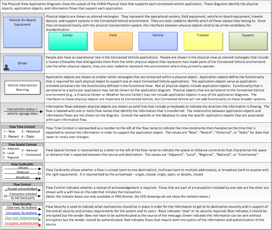
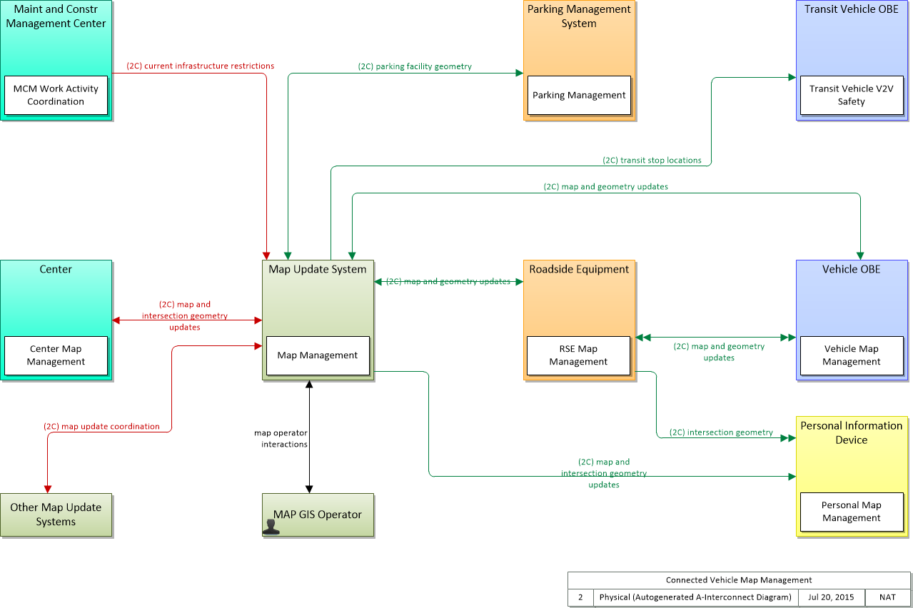
Physical
This is one way this application may be realized, but not the only way. There are other ways to build a given application and accomplish a stated objective.
The physical diagram can be viewed in SVG or PNG format and the current format is SVG. SVG Diagram
PNG Diagram
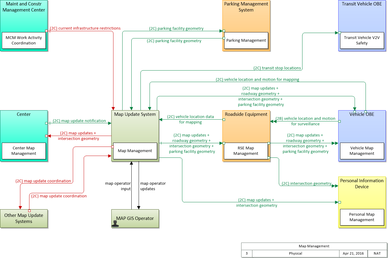
Includes Physical Objects:
| Physical Object | Class | Description |
|---|---|---|
| Center | Center | This general physical object is used to model core capabilities that are common to any center. |
| Maint and Constr Management Center | Center | The 'Maint and Constr Management Center' monitors and manages roadway infrastructure construction and maintenance activities. Representing both public agencies and private contractors that provide these functions, this physical object manages fleets of maintenance, construction, or special service vehicles (e.g., snow and ice control equipment). The physical object receives a wide range of status information from these vehicles and performs vehicle dispatch, routing, and resource management for the vehicle fleets and associated equipment. The physical object participates in incident response by deploying maintenance and construction resources to an incident scene, in coordination with other center physical objects. The physical object manages equipment at the roadside, including environmental sensors and automated systems that monitor and mitigate adverse road and surface weather conditions. It manages the repair and maintenance of both non-ITS and ITS equipment including the traffic controllers, detectors, dynamic message signs, signals, and other equipment associated with the roadway infrastructure. Weather information is collected and fused with other data sources and used to support advanced decision support systems. The physical object remotely monitors and manages ITS capabilities in work zones, gathering, storing, and disseminating work zone information to other systems. It manages traffic in the vicinity of the work zone and advises drivers of work zone status (either directly at the roadside or through an interface with the Transportation Information Center or Traffic Management Center physical objects.) Construction and maintenance activities are tracked and coordinated with other systems, improving the quality and accuracy of information available regarding closures and other roadway construction and maintenance activities. |
| MAP GIS Operator | Support | The 'Map GIS Operator' represents the person or people that manage GIS updates, supporting import and translation of source data, preparing the base map and information layers, and providing oversight and management for incremental releases of updated map data. |
| Map Update System | Support | The 'Map Update System' represents a provider of map databases used to support ITS services. It supports the provision of the map data that are used directly by vehicles (e.g., roadway and intersection geometry data sets), travelers (e.g., navigable maps used for route guidance and display maps used at traveler information points), system operators (e.g., map data used by Traffic Operators to monitor and manage the road network, and map data used by Fleet Managers to manage a vehicle fleet). It may represent a third-party provider or an internal organization that produces map data for agency use. Products may include simple display maps, map data sets that define detailed road network topology and geometry, or full geographic information system databases that are used to support planning and operations. |
| Other Map Update Systems | Support | Representing other distinct Map Update Systems, this object is intended to provide a source and destination for ITS information flows between peer map update providers. It enables cooperative information sharing between base map and specialized map providers and any other exchange of geographic information between map data providers. |
| Parking Management System | Field | The Parking Management System provides electronic monitoring and management of parking facilities. It supports an I2V link to the Vehicle that allows electronic collection of parking fees and monitors and controls parking meters that support conventional parking fee collection. It also includes the instrumentation, signs, and other infrastructure that monitors parking lot usage and provides local information about parking availability and other general parking information. This portion of the functionality must be located in the parking facility where it can monitor, classify, and share information with customers and their vehicles. It also interfaces with the financial infrastructure and broadly disseminates parking information to other operational centers in the region. Note that the latter functionality may be located in a back office, remote from the parking facility. |
| Personal Information Device | Traveler | The 'Personal Information Device' provides the capability for travelers to receive formatted traveler information wherever they are. Capabilities include traveler information, trip planning, and route guidance. Frequently a smart phone, the Personal Information Device provides travelers with the capability to receive route planning and other personally focused transportation services from the infrastructure in the field, at home, at work, or while en-route. Personal Information Devices may operate independently or may be linked with connected vehicle on-board equipment. |
| Roadside Equipment | Field | 'Roadside Equipment' (RSE) represents the Connected Vehicle roadside devices that are used to send messages to, and receive messages from, nearby vehicles using Dedicated Short Range Communications (DSRC) or other alternative wireless communications technologies. Communications with adjacent field equipment and back office centers that monitor and control the RSE are also supported. This device operates from a fixed position and may be permanently deployed or a portable device that is located temporarily in the vicinity of a traffic incident, road construction, or a special event. It includes a processor, data storage, and communications capabilities that support secure communications with passing vehicles, other field equipment, and centers. |
| Transit Vehicle OBE | Vehicle | The Transit Vehicle On-Board equipment (OBE) resides in a transit vehicle and provides the sensory, processing, storage, and communications functions necessary to support safe and efficient movement of passengers. The types of transit vehicles containing this physical object include buses, paratransit vehicles, light rail vehicles, other vehicles designed to carry passengers, and supervisory vehicles. It collects ridership levels and supports electronic fare collection. It supports a traffic signal prioritization function that communicates with the roadside physical object to improve on-schedule performance. Automated vehicle location enhances the information available to the transit operator enabling more efficient operations. On-board sensors support transit vehicle maintenance. The physical object supports on-board security and safety monitoring. This monitoring includes transit user or vehicle operator activated alarms (silent or audible), as well as surveillance and sensor equipment. The surveillance equipment includes video (e.g. CCTV cameras), audio systems and/or event recorder systems. It also furnishes travelers with real-time travel information, continuously updated schedules, transfer options, routes, and fares. In CVRIA, a separate 'Vehicle OBE' physical object supports the general V2V and V2I safety applications and other applications that apply to all vehicles, including transit vehicles. The Transit Vehicle OBE supplements these general capabilities with capabilities that are specific to transit vehicles. |
| Vehicle OBE | Vehicle | The Vehicle On-Board Equipment (OBE) provides the vehicle-based processing, storage, and communications functions necessary to support connected vehicle operations. The radio(s) supporting V2V and V2I communications are a key component of the Vehicle OBE. This communication platform is augmented with processing and data storage capability that supports the connected vehicle applications. In CVRIA, the Vehicle OBE includes the functions and interfaces that support connected vehicle applications for passenger cars, trucks, and motorcycles. Many of these applications (e.g., V2V Safety applications) apply to all vehicle types including personal vehicles, commercial vehicles, emergency vehicles, transit vehicles, and maintenance vehicles. From this perspective, the Vehicle OBE includes the common interfaces and functions that apply to all motorized vehicles. |
Includes Application Objects:
| Application Object | Description | Physical Object |
|---|---|---|
| Center Map Management | "Center Map Management" provides the map functionality necessary to support map updates and use within an operational center. It manages map data for the center and provides map data to center applications that use a map. | Center |
| Map Management | "Map Management" provides the GIS functionality necessary to support map data creation and management. It provides an operator interface that supports management of the map data and rendering of the maps under operator control and interfaces to external data sources, including the connected vehicle environment. | Map Update System |
| MCM Work Activity Coordination | "MCM Work Activity Coordination" disseminates work activity schedules and current asset restrictions to other agencies. Work schedules are coordinated with operating agencies, factoring in the needs and activities of other agencies and adjacent jurisdictions. Work schedules are also distributed to Transportation Information Centers for dissemination to the traveling public. | Maint and Constr Management Center |
| Parking Management | "Parking Management" detects and classifies vehicles at parking facility entrances, exits, and other designated locations within the facility. Current parking availability is monitored and used to inform drivers through dynamic message signs/displays so that vehicles are efficiently routed to available spaces. Parking facility information, including current parking rates and directions to entrances and available exits, is also provided to drivers. Coordination with traffic management supports local traffic control coordination in and around the parking facility. | Parking Management System |
| Personal Map Management | "Personal Map Management" supports map updates and makes current map and geometry data available to other applications. It manages map data for the device and provides map data to end-user applications that provide location-based services. | Personal Information Device |
| RSE Map Management | "RSE Map Management" provides the map functionality necessary to support map data updates to passing vehicles. It collects current map and geometry data and provides current map and geometry data to connected vehicles. | Roadside Equipment |
| Transit Vehicle V2V Safety | "Transit Vehicle V2V Safety" exchanges current vehicle location and motion information with other vehicles in the vicinity, uses that information to predict vehicle paths, and notifies the driver when the potential for an impending collision is detected. Information from on-board sensors (e.g., radars and image processing) are used to augment the V2V communications, if available. In addition to notifying the driver, control information can also be provided to support automated control functions that can avoid the collision. This object is similar to the "Vehicle Basic V2V Safety", but it accounts for crash scenarios that are unique to transit vehicles (e.g., Vehicle Turning Right in Front of Bus). It is also stop-aware since stop locations pose specific crash threats for transit vehicles. Finally, the detection and control algorithms, filters, and timing account for bus performance and risk profiles associated with remote vehicles that are unique to transit. | Transit Vehicle OBE |
| Vehicle Map Management | "Vehicle Map Management" supports map updates and makes current map and geometry data available to other applications. It manages map data on-board and provides map data to end-user applications that provide location-based services. | Vehicle OBE |
Includes Information Flows:
| Information Flow | Description |
|---|---|
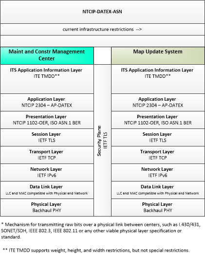
| current infrastructure restrictions | Restrictions levied on transportation asset usage based on infrastructure design, surveys, tests, or analyses. This includes standard facility design height, width, and weight restrictions, special restrictions such as spring weight restrictions, and temporary facility restrictions that are imposed during maintenance and construction. |
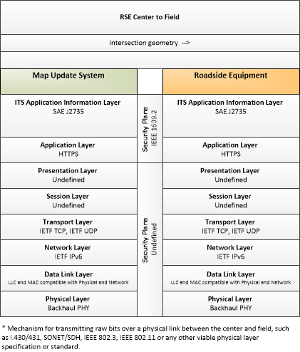
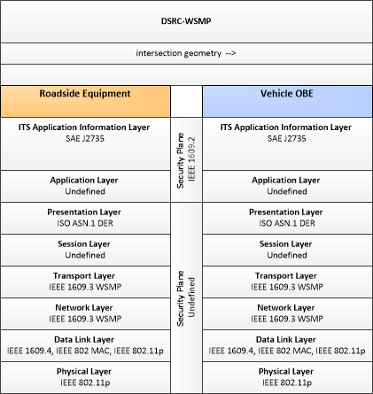
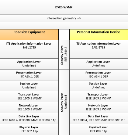
| intersection geometry | The physical geometry of an intersection covering the location and width of each approaching lane, egress lane, and valid paths between approaches and egresses. This flow also defines the location of stop lines, cross walks, specific traffic law restrictions for the intersection (e.g., turning movement restrictions), and other elements that support calculation of a safe and legal vehicle path through the intersection. |
| map operator input | The range of GIS operator inputs that support creation and update of navigable maps and management and distribution of the map data to end users. |
| map operator updates | Interactive display of base map and information layers and associated information that supports map development, management, and dissemination. |
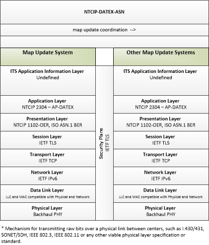
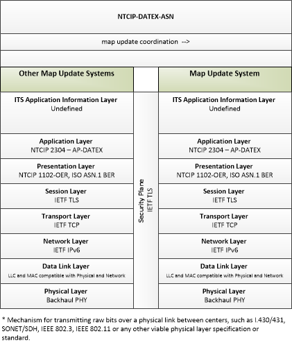
| map update coordination | Exchange of geographic information between map update systems. |
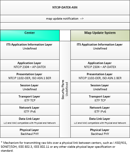
| map update notification | Notification of maintenance, construction, and other activities that will result in medium to long term changes to road location and configuration that may impact navigable maps. This flow includes the timing of the changes and precise enumeration of the location and configuration changes. |
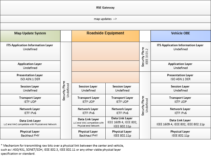
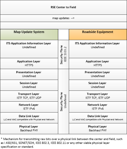
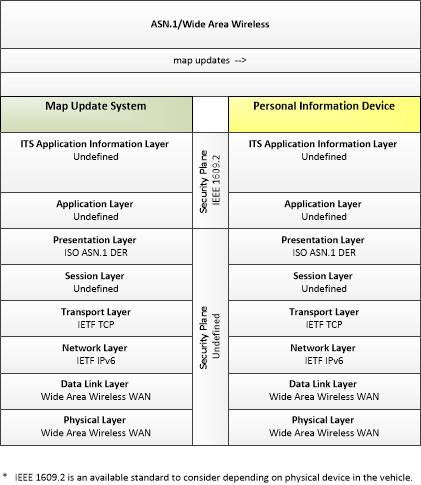
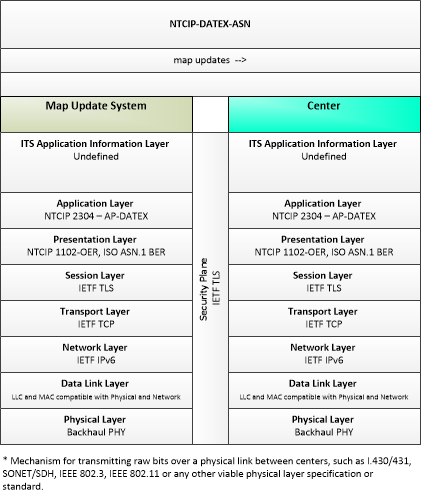
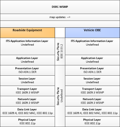
| map updates | Map update which could include a new underlying static or real-time map or map layer(s) update. |
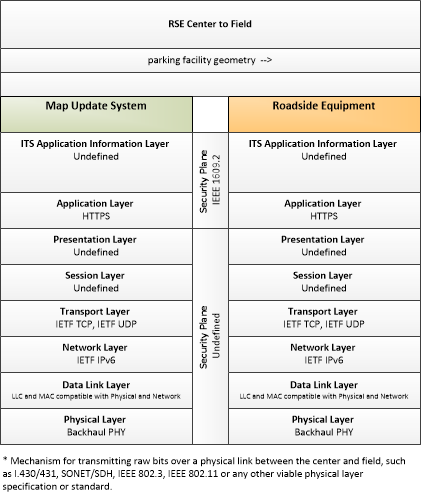
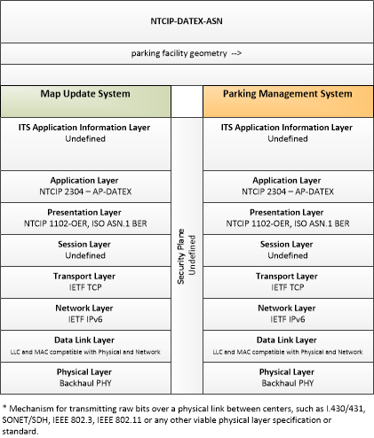
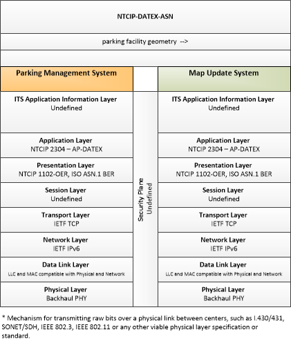
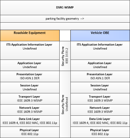
| parking facility geometry | Precise spatial description of a parking facility that locates each parking space and the ingress and egress routes that are used to travel to and from the spaces. |
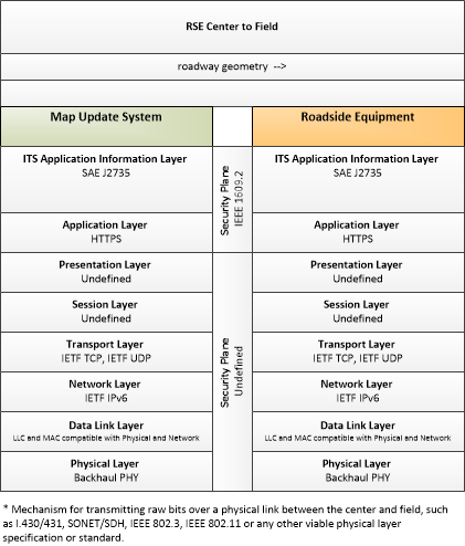
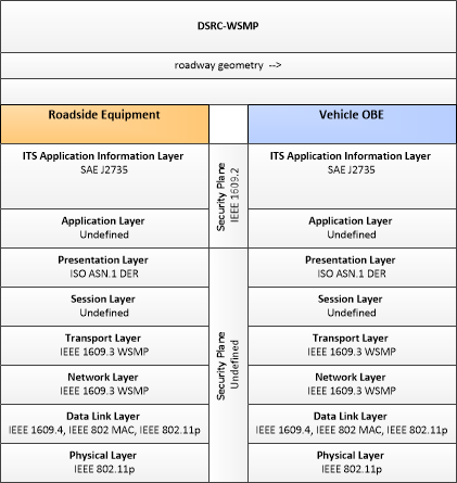
| roadway geometry | The physical geometry of a road segment that specifies the location and width of each lane, including normal lanes as well as special lanes for pedestrians and bicycles, transit vehicles, and trains. This flow also may include the curvature, grade, and superelevation or banking of the road segment. |
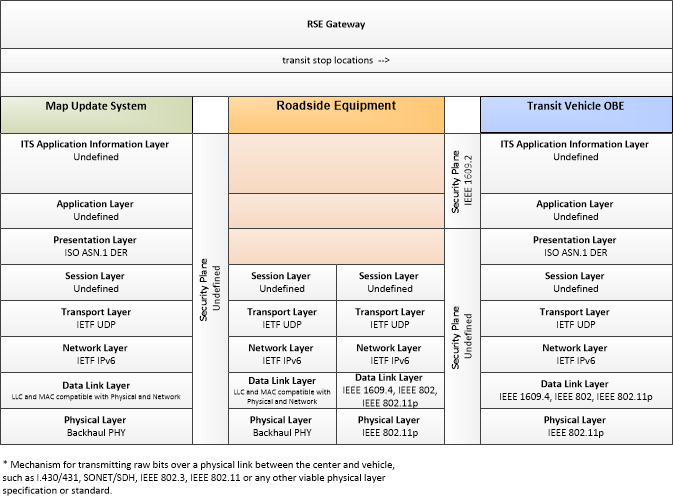
| transit stop locations | The current geographic location and dimensions of transit stops. This flow may also include the road geometry in the vicinity of the stops as needed to support transit vehicle safety applications when arriving at or departing from stops. |
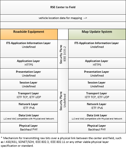
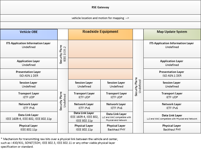
| vehicle location and motion for mapping | Vehicles may provide location and motion data independently using wide-area wireless communications to application/service providers who use the provided data to update their maps and maintain real-time traffic and road conditions information sourced from their client-base. |
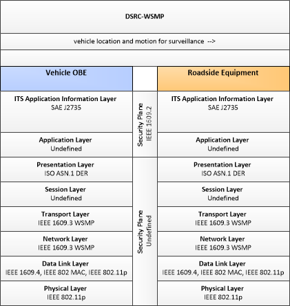
| vehicle location and motion for surveillance | Data describing the vehicle's location in three dimensions, heading, speed, acceleration, braking status, and size. This flow represents monitoring of basic safety data ('vehicle location and motion') broadcast by passing connected vehicles for use in vehicle detection and traffic monitoring applications. |
| vehicle location data for mapping | Aggregate vehicle location data collected to support map data creation and refinement. |
Application Interconnect Diagram
This is one way this application may be realized, but not the only way. There are other ways to build a given application and accomplish a stated objective.
The application interconnect diagram can be viewed in SVG or PNG format and the current format is SVG. SVG Diagram
PNG Diagram
Application Triples


Requirements
| Need | Requirement | ||
|---|---|---|---|
| N4.001 | Applications need to protect data they handle from unauthorized access. This is required to support applications that exchange sensitive information, such as personally identifying or financial information, which if intercepted could compromise the privacy or financial records of the user. | 4.001 | Applications that function by exchanging data between entities shall be able to exchange encrypted data between those entities. |
| N4.002 | Applications need to establish trust between entities that operate components of the application. Such trust relationships are necessary so that applications can be assured that entities are who they say they are, and therefore trust the source and data it receives. | 4.002 | Applications shall verify that, for each entity on which an application component is installed, that entity is trusted by the provider of the application. |
| 4.003 | Applications shall be able to digitally sign all messages sent between entities. | ||
| 4.004 | Applications shall be able to verify the digital signature of received messages. | ||
| 4.005 | Digital signatures used to ensure trust shall be generated independently of the application sending the message to be signed. | ||
| N4.003 | Applications need to revoke the trust relationship they have between entities when necessary. A trusted entity may operate in a fashion that indicates it should no longer be trusted, in which case applications must have a way of revoking that trust. | 4.006 | Applications shall identify entities that provide messages to the application that are improperly formatted. |
| 4.007 | Applications shall identify entities that provide messages to the application that are logically inconsistent. | ||
| 4.008 | Applications shall revoke personal trust (trust by the application) when a repeated pattern of messages from a given entity falls outside of the applications tolerances. | ||
| 4.009 | Applications shall be able to report suspicious behavior to third party authentication providers. | ||
| 4.010 | Applications shall be able to accept messages from the third party authentication provider that identifies entities unworthy of trust. | ||
| 4.011 | Applications shall be able to revoke trust between itself and an entity if that entity is identified by the third party authentication provider as untrustworthy. | ||
| N4.004 | All participants in the Connected Vehicle Environment need to operate on a common time base. Coordination of time between the entities that operate applications as well as those providing Core services prevents internal errors and enables time-sensitive interactions between application components. | 4.012 | All applications shall use the same time source as the basis for timing. |
| N4.068 | Connected Vehicle Map Management needs to provide map data to centers, field devices, personal devices, and connected vehicles. | 4.124 | Connected Vehicle Map Management shall send map information, map updates, and intersection geometry information to centers participating in Connected Vehicle applications. |
| 4.125 | Connected Vehicle Map Management shall send map information, map updates, roadway geometry, and intersection geometry information to roadside equipment participating in Connected Vehicle applications. | ||
| 4.126 | Connected Vehicle Map Management shall send map information, map updates, roadway geometry, and intersection geometry information to connected vehicles. | ||
| 4.127 | Connected Vehicle Map Management shall send map information, map updates, and intersection geometry information to personal information devices. | ||
| N4.069 | Connected Vehicle Map Management needs to coordinate map data across multiple map provider systems to create map data for delivery to various systems. | 4.128 | Connected Vehicle Map Management shall support coordination between Map Update Systems to provide an integrated map view for use by connected vehicle systems. |
Related Sources
- Signal Phase & Timing (SPaT) ConOps, Draft revD, 8/8/2011
Security
In order to participate in this application, each physical object should meet or exceed the following security levels.
| Physical Object Security | ||||
|---|---|---|---|---|
| Physical Object | Confidentiality | Integrity | Availability | Security Class |
| Security levels have not been defined yet. | ||||
In order to participate in this application, each information flow triple should meet or exceed the following security levels.
| Information Flow Security | |||||
|---|---|---|---|---|---|
| Source | Destination | Information Flow | Confidentiality | Integrity | Availability |
| Basis | Basis | Basis | |||
| Security levels have not been defined yet. | |||||