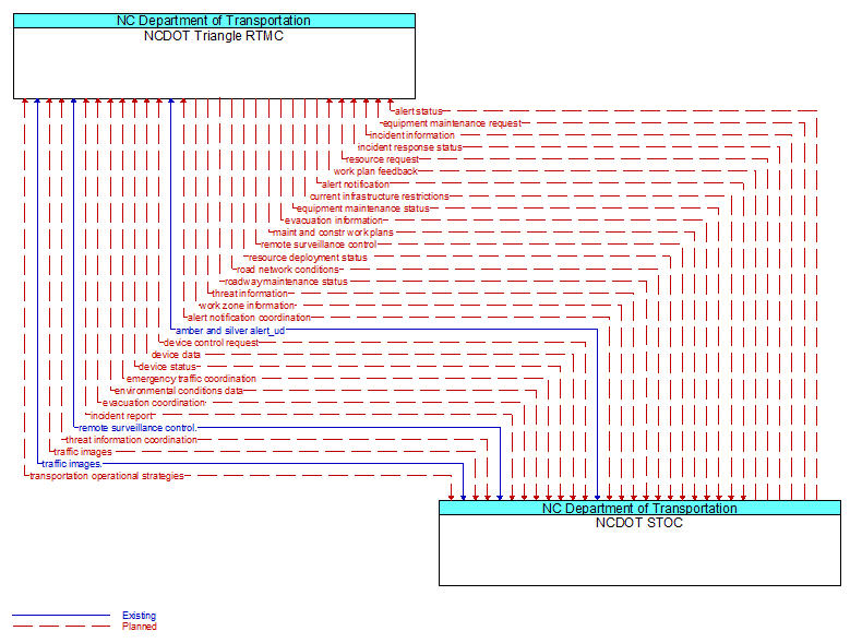
Interface: NCDOT Triangle RTMC - NCDOT STOC
Architecture Flow Definitions
alert notification (Planned) Applicable ITS Standards
Notification of a major emergency such as a natural or man–made disaster, civil emergency, or child abduction for distribution to the public. The flow identifies the alert originator, the nature of the emergency, the geographic area affected by the emergency, the effective time period, and information and instructions necessary for the public to respond to the alert. This flow may also identify specific information that should not be released to the public.
alert notification coordination (Planned) Applicable ITS Standards
Coordination of emergency alerts to be distributed to the public. This includes notification of a major emergency such as a natural or man–made disaster, civil emergency, or child abduction for distribution to the public and status of the public notification.
alert status (Planned) Applicable ITS Standards
Information indicating the current status of the emergency alert including identification of the traveler and driver information systems that are being used to provide the alert.
amber and silver alert_ud (Existing)
Amber alert information to be placed on dynamic message signs controlled by a traffic management element or on the emergency alert system (EAS).
current infrastructure restrictions (Planned) Applicable ITS Standards
Restrictions levied on transportation asset usage based on infrastructure design, surveys, tests, or analyses. This includes standard facility design height, width, and weight restrictions, special restrictions such as spring weight restrictions, and temporary facility restrictions that are imposed during maintenance and construction.
device control request (Planned) Applicable ITS Standards
Request for device control action
device data (Planned) Applicable ITS Standards
Data from detectors, environmental sensor stations, roadside equipment, and traffic control devices, including device inventory information.
device status (Planned) Applicable ITS Standards
Status information from devices
emergency traffic coordination (Planned) Applicable ITS Standards
Coordination supporting disaster response including evacuation and reentry. Includes coordination of special traffic control strategies that support efficient evacuation and reentry while protecting and optimizing movement of response vehicles and other resources responding to the emergency.
environmental conditions data (Planned) Applicable ITS Standards
Current road conditions (e.g., surface temperature, subsurface temperature, moisture, icing, treatment status) and surface weather conditions (e.g., air temperature, wind speed, precipitation, visibility) as measured and reported by fixed and/or mobile environmental sensors and aggregated by the data collector. Attributes relating to the data collection (and aggregation) are also included.
equipment maintenance request (Planned) Applicable ITS Standards
Identification of field equipment requiring repair and known information about the associated faults.
equipment maintenance status (Planned) Applicable ITS Standards
Current status of field equipment maintenance actions.
evacuation coordination (Planned) Applicable ITS Standards
Coordination of information regarding a pending or in–process evacuation. Includes evacuation zones, evacuation times, evacuation routes, forecast network conditions, and reentry times.
evacuation information (Planned) Applicable ITS Standards
Evacuation instructions and information including evacuation zones, evacuation times, and reentry times.
incident information (Planned) Applicable ITS Standards
Notification of existence of incident and expected severity, location, time and nature of incident. As additional information is gathered and the incident evolves, updated incident information is provided. Incidents include any event that impacts transportation system operation ranging from routine incidents (e.g., disabled vehicle at the side of the road) through large–scale natural or human–caused disasters that involve loss of life, injuries, extensive property damage, and multi–jurisdictional response. This also includes special events, closures, and other planned events that may impact the transportation system.
incident report (Planned) Applicable ITS Standards
Report of an identified incident including incident location, type, severity and other information necessary to initiate an appropriate incident response.
incident response status (Planned) Applicable ITS Standards
Status of the current incident response including a summary of incident status and its impact on the transportation system, traffic management strategies implemented at the site (e.g., closures, diversions, traffic signal control overrides), and current and planned response activities.
maint and constr work plans (Planned) Applicable ITS Standards
Future construction and maintenance work schedules and activities including anticipated closures with anticipated impact to the roadway, alternate routes, anticipated delays, closure times, and durations.
remote surveillance control (Planned) Applicable ITS Standards
The control commands used to remotely operate another center's sensors or surveillance equipment so that roadside surveillance assets can be shared by more than one agency.
remote surveillance control. (Existing)
The control commands used to remotely operate another center's sensors or surveillance equipment so that roadside surveillance assets can be shared by more than one agency.
resource deployment status (Planned) Applicable ITS Standards
Status of resource deployment identifying the resources (vehicles, equipment, materials, and personnel) available and their current status. General resource inventory information and specific status of deployed resources may be included.
resource request (Planned) Applicable ITS Standards
A request for resources to implement special traffic control measures, assist in clean up, verify an incident, etc. The request may poll for resource availability or request pre–staging, staging, or immediate deployment of resources. Resources may be explicitly requested or a service may be requested and the specific resource deployment may be determined by the responding agency.
road network conditions (Planned) Applicable ITS Standards
Current and forecasted traffic information, road and weather conditions, and other road network status. Either raw data, processed data, or some combination of both may be provided by this flow. Information on diversions and alternate routes, closures, and special traffic restrictions (lane/shoulder use, weight restrictions, width restrictions, HOV requirements) in effect is included.
roadway maintenance status (Planned) Applicable ITS Standards
Summary of maintenance fleet operations affecting the road network. This includes the status of winter maintenance (snow plow schedule and current status).
threat information (Planned) Applicable ITS Standards
Threats regarding transportation infrastructure, facilities, or systems detected by a variety of methods (sensors, surveillance, threat analysis of advisories from outside agencies, etc.
threat information coordination (Planned) Applicable ITS Standards
Sensor, surveillance, and threat data including raw and processed data that is collected by sensor and surveillance equipment located in secure areas.
traffic images (Planned) Applicable ITS Standards
High fidelity, real–time traffic images suitable for surveillance monitoring by the operator or for use in machine vision applications. This flow includes the images and meta data that describes the images.
traffic images. (Existing)
High fidelity, real–time traffic images suitable for surveillance monitoring by the operator or for use in machine vision applications. This flow includes the images and the operational status of the surveillance system.
transportation operational strategies (Planned) Applicable ITS Standards
Operational strategies for each operating agency in a transportation corridor, downtown area, or other travel–impacted area, providing an integrated operations strategy for the freeways, tollways, arterials, transit services, parking facilities, and other transportation–related facilities in the area. These strategies can include dynamic adjustments to transit fares and tolls, parking fees and restrictions, dynamic lane restriction changes, and other active demand management strategies.
work plan feedback (Planned) Applicable ITS Standards
Comments and suggested changes to proposed construction and maintenance work schedules and activities. This information influences work plan schedules so that they minimize impact to other system operations and the overall transportation system.
work zone information (Planned) Applicable ITS Standards
Summary of maintenance and construction work zone activities affecting the road network including the nature of the maintenance or construction activity, location, impact to the roadway, expected time(s) and duration of impact, anticipated delays, alternate routes, and suggested speed limits. This information may be augmented with images that provide a visual indication of current work zone status and traffic impacts.